Marshfield Photography Guide: Best Photo Spots, Sunrises & Sunsets
Marshfield is an easy town to photograph once you understand its one organizing rule: the light comes in two shifts. The ocean side of town faces east, out over the Atlantic — that is sunrise country. The river side faces west, over the South River and its salt marsh — that is sunset country. A photographer based here does not chase the light around the map; the map is already arranged around the light. Add the second clock, a roughly nine-foot tide that rebuilds every beach and marsh twice a day, and you have the whole method of this guide: pick your side of town by the hour, and pick your hour by the tide.
Everything below is built from the places our Things to Do in Marshfield guide and its village chapters have already verified — where each spot is, how its access works, and what the light does there. Each spot links to its own village guide for the full local detail. Bring a tide chart as faithfully as you bring a lens: the closest NOAA predictions are for Brant Rock / Green Harbor River, station 8446009, and on this coast the tide is not background — it is half the composition.
Sunrise: first light over the Atlantic at Rexhame
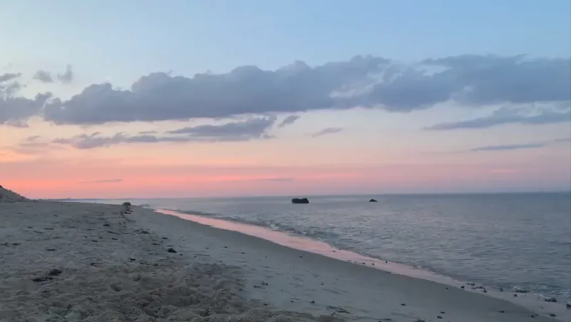
Start where the town starts its day. Rexhame Beach faces the Atlantic directly, and the live rule of the beach is the photographer's rule too: first light over open water, and the flats to yourself. Come on a falling or low tide and the sunrise has a foreground — wide hard sand, sandbars, and marsh creeks draining through the shallows, with wading birds feeding in them. The dune line runs north toward Humarock and gives the frame its leading edge. Public access is the town lot at the end of Standish Street — the lot is the visitor entrance, and the marked paths from it are the way onto both sides of the beach. The shoreline below, running along the dunes, is the view that greets you:
Two quieter sunrise variations, both nearby. Fieldston Beach, about an 8-minute drive south, is the same east-facing Atlantic with a fraction of the company — a small village beach where a dawn shoot is likely to be a solo one. And for elevation, Coast Guard Hill (about a 5-minute drive from Rexhame) is a short trail up the former Coast Guard property opening onto views over Rexhame, Humarock, the South River, and Massachusetts Bay — the one perch in town where a single frame can hold the ocean and the river system that the rest of this guide treats as two separate shoots.
Sunset: the South River marsh
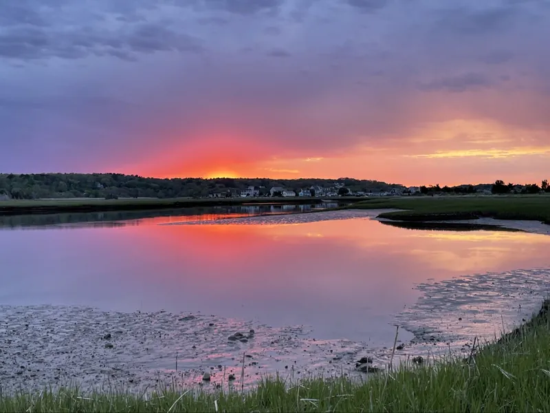
For the other end of the day, cross the same barrier beach you started on. Rexhame's river side — reached by the marked paths through the dunes from the town lot — is where the sunsets land: the sun drops over the South River marsh, the grass goes gold, and Humarock sits across the water in silhouette. The logistics even cooperate: non-resident parking at the lot drops to $10 after 5 PM, which makes the evening shoot the cheapest one in town. Photograph it two ways. At higher water the river runs deep and full and the marsh reads as a single sheet of reflected sky. At low water the creeks drain, the mud and cordgrass texture come out, and still pools hold the color after the sky itself has faded — the sunset below was made in exactly that low-tide stillness:
The paddler's version of the same scene is in our South River kayaking guide: from the river-side launch, the marsh at evening is a shoot from water level, with the barrier beach behind you. Time any river shoot around the tide rather than the clock alone — high tide at Rexhame arrives about 45 minutes after Boston's.
The working harbor: Green Harbor
Green Harbor is the town's documentary subject — a real harbor first and a beach village second, about a 12-minute drive from Rexhame. The fleet moves through the channel at hours when the rest of the town is asleep, which sets the shoot: be at the Marshfield Town Pier on the inner harbor before the beach umbrellas exist anywhere, and the frames are boats, rigging, gulls, and crews working in first light. The marina at Safe Harbor Green Harbor (239 Dyke Road) and the charter boats — Big Fish Charters and Black Rose Fishing Charters among them — supply the working detail: traps, tackle, hulls, and the Stellwagen fleet coming and going. Walk out toward the jetties and harbor mouth for the harbor's other composition, where moving harbor water meets the ocean along the rocks — the spot the fishing chapter rates best at first light and on an outgoing tide, and the light agrees. The Lobster Pound on Beach Street and the picnic tables by the Cut River finish the set: this is the chapter to shoot in the blue hour at either end of the day, when the harbor is working and the tourists are not yet — or no longer — in it.
The seawall: Brant Rock and Ocean Bluff
The Ocean Street shore is the town's portrait strip. In Brant Rock, the seawall and the Esplanade walk along Ocean Street are the village's front porch — shoot it in the evening, when the decks at Venus II, The Jetty, and The Fairview fill, the light goes across Cape Cod Bay, and the whole village takes its after-dinner stroll in front of your lens. It is street photography at beach scale: bar pizzas, live music spilling out, the bay behind everything. A few minutes north, Ocean Bluff is the same seawall with the volume off — a residential shore of houses above the water, best early and late in the day when the light is on the bay and the street is quiet, and the stretch through Sunrise Beach between Fieldston and the bluff is where skimboarders and surfers work the shore in summer. Shoot Brant Rock for the life and Ocean Bluff for the calm; they are five minutes and one whole mood apart.
The long shore: Humarock and Fourth Cliff
Humarock, about a 10-minute drive via Ferry Street and the Sea Street Bridge, is the landscape shoot: three miles of barrier beach with the Atlantic in front and the South River behind, so a single walk produces both weathers of light — hard ocean brightness on one side, still marsh softness on the other. Work it early or late, when the long sand throws long shadows and the cottage shoreline reads as one continuous line. At the north end, the beach meets the mouth of the North River below Fourth Cliff — the most dramatic water in town, all current, sandbars, and channels — and the cliff itself carries the history: a lifesaving station stood at Fourth Cliff from 1879, its crews patrolling this beach on foot. One discipline for this chapter, borrowed from the beach guide and meant seriously: the river mouth is a place to admire with a camera or a rod, not a swim — the currents there are strong and unpredictable, and the guarded swimming area down the sand is where the water work belongs.
Marsh and sanctuary wildlife
For wildlife, Marshfield's two Mass Audubon sanctuaries do the work, and both reward the same hours as the beaches. The Daniel Webster Wildlife Sanctuary — 576 acres of grasslands, wetlands, and woodland with 3.5 miles of trails and observation platforms — is the bird photographer's base: the guide rates its bird and wildlife viewing excellent especially around dawn and sunset, which is when the platforms earn their keep and the grassland light is at its lowest and warmest. Admission is free for Mass Audubon members, with a small fee for nonmembers. The North River Wildlife Sanctuary — 225 acres, more than two miles of trails through salt marsh and woods — adds the riverside viewing platform where seals can sometimes be seen, and the marsh-edge frames the Daniel Webster grasslands do not give you. Egrets and herons work these marshes and the Rexhame shallows at low tide; the method is patience and a long lens from the paths and platforms, not a pursuit across the marsh. Both sanctuaries are covered in the main guide's trails chapter, and the Hills chapter visits the North River sanctuary in its own setting in our Marshfield Hills guide.
Tides, seasons, and the second clock
Tides first. Around low tide, the ocean beaches open into wide flats and sandbars — the hour for reflections in wet sand, patterns in the drained creeks, and the longest walking compositions. Around high tide, the beaches narrow to their upper strip while the marsh fills to the grass tops and the rivers run deep — the hour for full-marsh minimalism and for any shoot involving a launch. Neither is the "good" tide; they are two different locations wearing the same name, twice a day.
Then seasons. Summer brings the haze, the crowded seawall evenings, and the year's most theatrical single night: July 3rd, when bonfires and informal fireworks run up and down the beaches at Rexhame, Green Harbor, Fieldston, and Brant Rock from dusk — shoot it as a spectator of a local tradition, from the sand, as the displays reflect off the wet shore. Autumn trades the crowds for marsh color and the fall migration through the sanctuaries, with cranberry harvest country — guided bog tours run from mid-September into the fall — a short drive inland for the one saturated-red landscape New England grows on purpose. Winter is the minimalist season: the beaches unstaffed and empty, the walking — ocean one way, marsh the other — there all year, and Green Harbor still working at dawn, which is why its off-season chapter in the village guide reads like a photographer's note. Spring belongs to the returning birds and the harbor waking up. The town photographs twelve months a year; only the wardrobe changes.
Access and etiquette: shoot like a local
- Stay on the marked paths. The dunes are the beach's structure, and their beach grass is fragile — the town's beach page notes that even breaking a single blade can kill the plant, and trampled grass means eroding dunes. Cross on the marked paths and crossovers, and respect seasonal closures around nesting areas.
- Use the public entrances. At Rexhame, the town lot is the visitor entrance and the only public access point; other paths and dune crossings in the neighborhood belong to residents and their guests. The same respect applies in every village: photograph the shore from the public shore, not through yards or down unmarked paths.
- Mind the working waterfront. Green Harbor's pier, marina, and boats are workplaces. Shoot the harbor from its public edges, give crews and gear a wide berth, and never treat a working boat as a prop you can board or rearrange.
- Wildlife distance is the technique. Birds and seals photographed from paths, platforms, and the shore with a long lens stay; wildlife chased across a marsh leaves. If the subject is moving away from you, the photo is over.
- Leave no trace of the shoot. Pack out what you packed in, leave gates, gear, and beach furniture as you found them, and let the next photographer's sunrise look like yours did.
Where to stay for the light
Photography here is a game of short drives at unsocial hours, which makes the base matter. The Egret's Nest sits in Rexhame, a 5-minute walk from the town beach — close enough that the sunrise shoot is a walk with a tripod, and the sunset shoot is the same walk in reverse, across the dunes to the river side. Green Harbor's harbor mornings are about a 12-minute drive, Brant Rock's seawall evenings about 8, Humarock about 10, and the sanctuaries about 15. One base, both shifts of light, no commute worth the name: that is the working arrangement this guide assumes, and it is a good one.
Keep exploring
- Rexhame Beach Guide — parking, access, and tides at the sunrise-and-sunset beach
- Green Harbor Village Guide — the working harbor, pier, and jetties
- Brant Rock Village Guide — the seawall and the Ocean Street strip
- Ocean Bluff Village Guide — the quiet seawall shore
- Fieldston Village Guide — the quiet sunrise beach
- Humarock Beach Guide — three miles of barrier beach and Fourth Cliff
- Marshfield Hills Guide — the North River sanctuary country
- Things to Do in Marshfield, MA — the full guide
Related Guides
- Rexhame Beach Guide — Parking, public access, lifeguards, tides, and the best times to go — the complete visitor guide to Marshfield's home beach.
- Marshfield Hills Village Guide — The historic inland village: the 1853 general store, the North River sanctuaries, and the old stagecoach roads.
- Brant Rock Village Guide — Ocean Street's beach, esplanade, and seafood institutions — plus the wireless-station history on Blackman's Point.
- Green Harbor Village Guide — Marshfield's working harbor: the lobster pound, the dike, the town pier, and a broad resident beach.
Stay near Rexhame Beach
The Egret's Nest, a renovated Marshfield coastal home a 5-minute walk from Rexhame Beach; summer weeks from $2,415.
Last locally reviewed: October 2026.